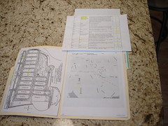
In this simple file folder for Southborough Rural Cemetery, I have placed a copy of the map of the cemetery, a list of persons whose graves I am looking for, driving directions and a printout of the cemetery area from Google Maps. On the front (not seen in this photo), I have a "shipping label" Avery #8163 2" x 4" affixed information label with the basic information about the cemetery. Items are firmly stapled to the folder. I can always remove them with the staple puller later on if needed.
It didn't hurt that Find a Grave already had a page for this cemetery AND a great photo of the cemetery sign. Thanks to the volunteers for this page.
I used to assume that once I visited a cemetery, I was "done" with it. Wrong. I have never been to a cemetery just once. It is like genealogy itself; it is never complete. Now, I assume I am going back. Of course, this particular cemetery is only about 10 minutes from home, so since the "location" day [defined as the day where we just find the cemetery], was raining, I didn't do all of the research I needed since I WANT to go back.
This cemetery was easy to find. Google Maps is really getting better and placing the name of the cemetery on the map and if it is a large cemetery, the interior roads are visible. I felt that we could safely drive our car around inside even if it was raining too much to get out. [Google Map of the area around this cemetery]
But, to make this folder, I spent quite a lot of time gathering as much as I could about the actual place. The Southborough Historical Society Web site made this very easy. I SO wish everything could be like this...
So, with a few names of my husband's ancestors, the file folder, the cemetery bag and my camera we set out to find it. I set our GPS to 11 Cordaville Road, Southborough, MA and noted the time we left.

No comments:
Post a Comment